

A Field of Play design goes through multiple stages before the design engineers deliver documentation ready for the contractor to construct the works.
Continually assessing and addressing risks at the start and throughout the design phase of your project is essential to deliver a project on time and within budget. Understanding the risks and taking steps to mitigate them will provide the contractor with a detailed scope of work. They can develop a more precise construction program and submit a competitive contract sum without the need for allowances to cover the risk of these unknowns. Identifying these risks will also reduce the number of variations throughout the construction phase.
In this post, we will focus on one key risk mitigation area in your project's design phase: site investigations.
Undertake site investigations to mitigate risks
Initial site investigations are a critical part of the risk assessment process, and when done right, they may highlight several prominent issues linked to your site that can help be managed or eradicated before the construction stage.
Site investigations can range in cost and in time to undertake, so finding the right balance is key, as is the understanding that even with the most thorough site investigations, there will still be unknown risks that need to be considered.
Most work associated with site investigations will occur before the design phase commences to ensure budgets are concise.
Some typical site investigations methods can include:
- Aerial photography assessment
- Site walkovers
- Cadastral feature survey
- In-ground utility locating
- Geotechnical investigations
- Environmental investigation to determine risks associated with contamination
- Arborist reporting and tree root mapping
- Engage with locals to establish site history
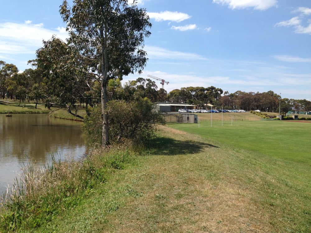 Site inspection organised for the upgrade and development of Deakin University's sporting facility.
Aerial photography to help produce high-level sketch designs
In recent years services such as Nearmap and MetroMap have been providing access to high-resolution and frequently updated images of our cities and regional areas. This imagery can be georeferenced into CAD software giving your engineers a cost-effective method to quickly assess the site and its constraints, and can be used to produce high-level sketch designs prior to a feature survey being generated.
There can be times when it can be more important to establish site constraints using this method before attending the site. This will ensure that when you are on-site with your engineers, the time spent will be focused on the critical conflict and tie-in points occurring between the design and the existing features.
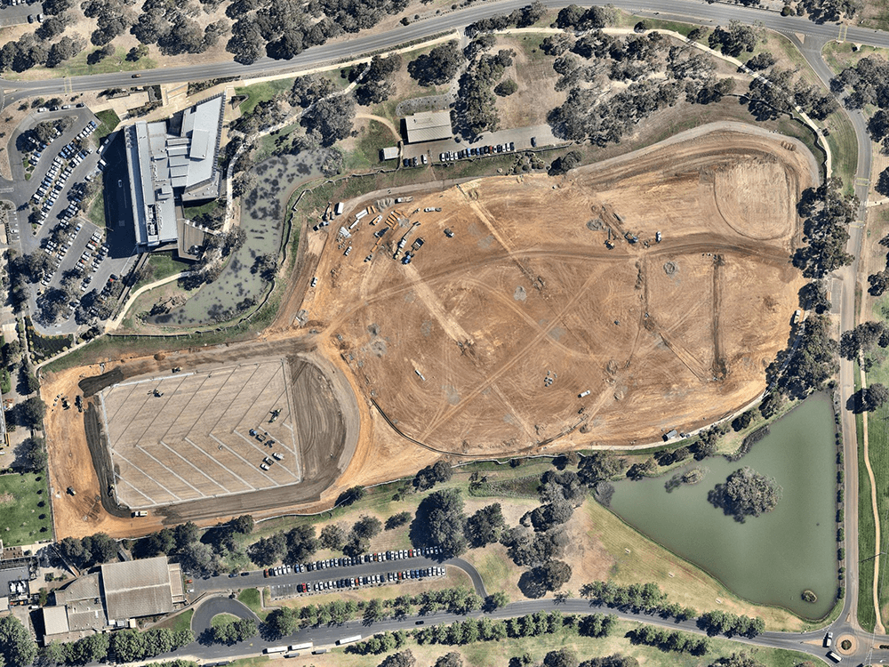 Aerial photography taken as part of the upgrade and development of Deakin University's sporting facility.
Site walkover to cross-reference details
One of the most effective methods to start your project on the right foot is to set up a meeting with your engineers and walk the site with them. If they have already produced a concept sketch, ensure you have this on hand to discuss key critical conflict and tie-in points. Use this time to reinforce the key project outcomes you and your stakeholders want to achieve.
Your engineers will use this time to take plenty of site photos. Getting good site photos and sharing these with their team is crucial as they can use their photos to cross-reference details within the feature survey.
Cadastral, feature and level survey for gathering more details
A must for any field of play is detailed design. Without this data, the design will be nothing more than guesswork. The survey will include details about the site, such as:
- Boundaries of properties with neighbours (titles)
- Easements, which can include sewer and drainage which cross your site
- Ground levels
- Contours
- Existing structures
- Fences
- Overhead and underground utilities
- Stormwater infrastructure
- Trees etc.
Whilst the survey will provide a good base to complete detail design, some additional steps may be required to gather extra data as there can some gaps in the data collected that may impact your project.
The gaps in data to look out for include some recommendations for collecting this data:
- Drainage infrastructure without invert levels. Prior to the survey, have someone check that all the stormwater pits can be easily opened and provide confirmation to the surveyor. This will allow them to access all the pits when they are on-site and take line and level points of the drainage pipes and pits.
- Underground utilities. You will not often have a site with as-built surveys to provide an accurate layout of underground utilities. A ‘Dial Before You Did’ request can help fill the gaps, but it has its own quality limitations. You will need to engage a specialist in service locating to provide more accurate utility data.
- Tree roots. Many fields of play projects come with very high tolerance surface requirements, ensuring that tree roots won’t impact construction and/or the future surface. If there are trees within proximity to your project, you will likely need an Arborist to assess these trees, who can provide further recommendations for Non-Destructive Digging methods to assess existing tree roots.
Service locating to complete information gathered via surveys
In-ground utilities, in their entirety, will not be picked up in a standard Cadastral feature survey. Additional steps need to be taken using various methods to collect this information.
Not all subsurface utility data is collected to the same level of accuracy, and the methods used can vary significantly in costs, so understanding the project risk associated with the existing site utilities is important to ensure you collect the right type of data without over-spending for it.
AS 5488-2019 sets out four quality levels Class A, B, C and D, with A being the highest level of accuracy.
Where utilities appear to create high-risk conflict points with the project layout may require a Class A level of accuracy, this will require non-destructive excavation (potholing) methods to locate the top of service and take a 3d survey point of this location.
Some projects will only require Class D quality level, which can be gathered using "Dial before you dig" (DBYD) plans, but this information should only be treated as indicative.
Geotechnical investigation to understand the surface tolerances
One of the biggest risk items to your field of play project comes from the physical characteristics of the soil it is built on due to the cost implications during construction and the risk associated with surface tolerances sporting requirements for most of the non-turf fields of play.
Gaining an understanding of these physical characteristics will be completed with a geotechnical investigation. The data from this will be used by your engineers to design the field of play profile and will feed into their 3d design to minimise the costs associated with earthworks.
Environmental investigation to assess the soil's contamination levels
Another large risk item that needs to be considered for your field of play project is the potential for contaminated soils to be present on site. Contaminated soils can add substantially to the costs of removing site material or result in timely design changes to reshape the 3d model to keep this material on-site if possible.
Understanding the site's history is a good first step to establishing the risk profile, but beyond this, an environmental investigation will need to be carried out to assess the soil's contamination levels.
Environmental investigation can be expensive and need to be completed within the material that will be removed from site, so speak to your design engineers about the preferred time to undertake such an assessment.
Tree categorisation and tree root locating to reduce the risk of damaging the local flora during construction
The local flora, such as trees, is often an element to consider when entering the detailed design phase. Field of play projects look to maximise usable space, so conflict between the location of trees and the field of play layout will occur.
Understanding the types of trees and their root mass is key to reducing the risk associated with damaging the tree during construction or the tree damaging the field of play pavement over time. This is an important point to consider because many fields of play projects have high tolerance surface requirements, which tree roots could affect, resulting in a non-conforming surface.
An arborist will be required to assess the trees and provide advice to assist with this. Beyond this, non-destructive digging and tree root trimming may be required.
Enquiring about local knowledge to gain valuable site information
Enquiring and respecting local knowledge means exchanging with stakeholders, locals living around the area, and anyone else involved in the facility's maintenance. They usually hold valuable information about sites that the other methods above may not have helped you uncover yet.
This is considered an essential step of a site investigation as it could help highlight conditions on the project that no one knew or heard about before.
Feel free to contact us if you have any questions or any feedback on this question: we’re curious to hear your thoughts!
Return to the main blog page.